The Union Neighborhood Vision Plan
Consultation has concluded
Consultation has concluded.
Thank you to everyone who participated in the process. For upcoming Planning Commission and City Council meetings on this plan, please visit LakewoodSpeaks.org.
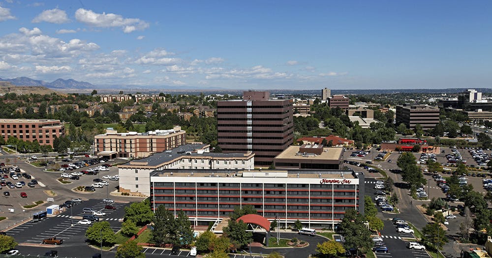
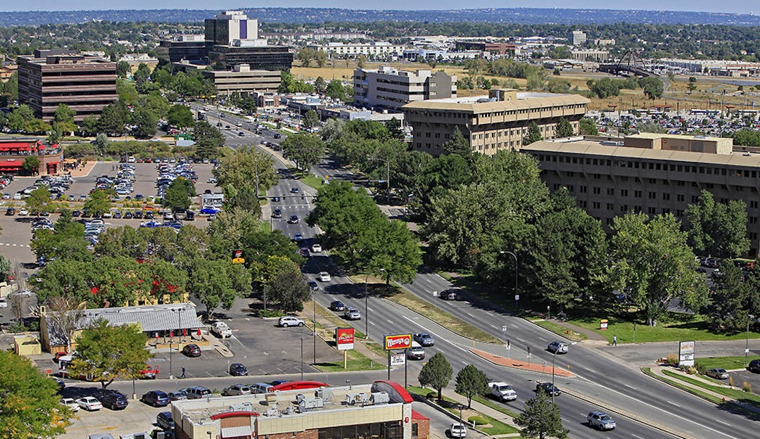
Union Boulevard, from West Sixth Avenue to West Alameda Avenue, is an active, busy area with office buildings, hotels, apartments, restaurants and numerous other businesses. Changes in the neighborhood and what’s in store for its future have prompted concerns and community conversations about this high-profile area. As a result, Lakewood is launching a community planning effort called the Union Neighborhood Vision Plan to work with the neighborhood to develop a long-range vision for the future.
The goal of this planning effort is to discuss how the neighborhood would like to see the area evolve over the next 20 years, and it will cover the following topics:
- How should the neighborhood function?
- What type of uses for the land should be encouraged?
- What should the design of the buildings look like?
- What types of amenities are important to enhance the neighborhood?
- Do there need to be changes to make walking in the neighborhood easier and safer?
We want to involve those who live and work in this neighborhood to develop this plan. This website will help residents, business owners and community members participate in this process and keep them informed about how their ideas and comments are shaping the plan.
You can participate in a number of ways:
- Attend upcoming community meetings.
- Take online surveys (click here).
- Visit the “Ask a Question” section (click here).
- Visit this site regularly for survey and meeting summaries.
- Subscribe to this project to receive email updates (right side toolbar).
Have a question? Ask us here! We'll answer your question within two business days. Please note that your questions will be visible to the public.
-
Share Hello, As a resident on the Union Corridor who supports sustainable initiatives and makes every effort to “walk the talk”, I ride my bike the federal center station before heading into Denver for work, and riding further from there. Often times I will skip the train and ride the whole way. I believe the biking trend is only growing, which is great, ad it should be supported. My question is this, will the bike paths within the planning areas 1, 2 and 3 along Union as well as Van Gordon be repaved or improved in any way? A related suggestion would be to have increased considerations given to signage and cross walks with regard to pedestrians and bicyclists. The crossings near 6th in particular, but to include all crossings. Thank you, on Facebook Share Hello, As a resident on the Union Corridor who supports sustainable initiatives and makes every effort to “walk the talk”, I ride my bike the federal center station before heading into Denver for work, and riding further from there. Often times I will skip the train and ride the whole way. I believe the biking trend is only growing, which is great, ad it should be supported. My question is this, will the bike paths within the planning areas 1, 2 and 3 along Union as well as Van Gordon be repaved or improved in any way? A related suggestion would be to have increased considerations given to signage and cross walks with regard to pedestrians and bicyclists. The crossings near 6th in particular, but to include all crossings. Thank you, on Twitter Share Hello, As a resident on the Union Corridor who supports sustainable initiatives and makes every effort to “walk the talk”, I ride my bike the federal center station before heading into Denver for work, and riding further from there. Often times I will skip the train and ride the whole way. I believe the biking trend is only growing, which is great, ad it should be supported. My question is this, will the bike paths within the planning areas 1, 2 and 3 along Union as well as Van Gordon be repaved or improved in any way? A related suggestion would be to have increased considerations given to signage and cross walks with regard to pedestrians and bicyclists. The crossings near 6th in particular, but to include all crossings. Thank you, on Linkedin Email Hello, As a resident on the Union Corridor who supports sustainable initiatives and makes every effort to “walk the talk”, I ride my bike the federal center station before heading into Denver for work, and riding further from there. Often times I will skip the train and ride the whole way. I believe the biking trend is only growing, which is great, ad it should be supported. My question is this, will the bike paths within the planning areas 1, 2 and 3 along Union as well as Van Gordon be repaved or improved in any way? A related suggestion would be to have increased considerations given to signage and cross walks with regard to pedestrians and bicyclists. The crossings near 6th in particular, but to include all crossings. Thank you, link
Hello, As a resident on the Union Corridor who supports sustainable initiatives and makes every effort to “walk the talk”, I ride my bike the federal center station before heading into Denver for work, and riding further from there. Often times I will skip the train and ride the whole way. I believe the biking trend is only growing, which is great, ad it should be supported. My question is this, will the bike paths within the planning areas 1, 2 and 3 along Union as well as Van Gordon be repaved or improved in any way? A related suggestion would be to have increased considerations given to signage and cross walks with regard to pedestrians and bicyclists. The crossings near 6th in particular, but to include all crossings. Thank you,
Kweck asked almost 6 years agoHello! Thank you for your question on bike connectivity in the Union corridor. The city completed a Union Area Transportation Study in 2018 that addresses mobility issues in the area including vehicular, pedestrian and bicycle connectivity. A copy of the study can be found here. I would suggest you contact John Padon with the Traffic Engineering division with any specific follow-up questions - he can be reached at Jonpad@lakewood.org or at 303-987-7986. Thanks!
-
Share This is about driving in the area and parking. Driving on the streets surrounding the area is generally not an issue, though there are exceptions-such as right lane traffic southbound on 6th approaching Alameda. It feels like the developers have been allowed to create a maze of smaller routes to get to the traffic lights from businesses set back from the main roads. From a drivers perspective there does not seem to be a plan-as getting in and out of places can be very awkward such as by the Wendys and the old Pizza Hut. Additionally the parking on the east side of the street by the small plazas between S Taft and the new Marriott hotel are very difficult to get in and out of. Extremely narrow entrances and you block traffic turning in. The whole intersection in the parking area between the KS and the Arc and then the four way by the McDonalds is difficult to navigate-odd angles, short turning radiuses. I realize that not much can be done in these established places, but if any changes are to be made these sorts of items should corrected and new development needs to be better integrated. Are there plans to correct any of this? on Facebook Share This is about driving in the area and parking. Driving on the streets surrounding the area is generally not an issue, though there are exceptions-such as right lane traffic southbound on 6th approaching Alameda. It feels like the developers have been allowed to create a maze of smaller routes to get to the traffic lights from businesses set back from the main roads. From a drivers perspective there does not seem to be a plan-as getting in and out of places can be very awkward such as by the Wendys and the old Pizza Hut. Additionally the parking on the east side of the street by the small plazas between S Taft and the new Marriott hotel are very difficult to get in and out of. Extremely narrow entrances and you block traffic turning in. The whole intersection in the parking area between the KS and the Arc and then the four way by the McDonalds is difficult to navigate-odd angles, short turning radiuses. I realize that not much can be done in these established places, but if any changes are to be made these sorts of items should corrected and new development needs to be better integrated. Are there plans to correct any of this? on Twitter Share This is about driving in the area and parking. Driving on the streets surrounding the area is generally not an issue, though there are exceptions-such as right lane traffic southbound on 6th approaching Alameda. It feels like the developers have been allowed to create a maze of smaller routes to get to the traffic lights from businesses set back from the main roads. From a drivers perspective there does not seem to be a plan-as getting in and out of places can be very awkward such as by the Wendys and the old Pizza Hut. Additionally the parking on the east side of the street by the small plazas between S Taft and the new Marriott hotel are very difficult to get in and out of. Extremely narrow entrances and you block traffic turning in. The whole intersection in the parking area between the KS and the Arc and then the four way by the McDonalds is difficult to navigate-odd angles, short turning radiuses. I realize that not much can be done in these established places, but if any changes are to be made these sorts of items should corrected and new development needs to be better integrated. Are there plans to correct any of this? on Linkedin Email This is about driving in the area and parking. Driving on the streets surrounding the area is generally not an issue, though there are exceptions-such as right lane traffic southbound on 6th approaching Alameda. It feels like the developers have been allowed to create a maze of smaller routes to get to the traffic lights from businesses set back from the main roads. From a drivers perspective there does not seem to be a plan-as getting in and out of places can be very awkward such as by the Wendys and the old Pizza Hut. Additionally the parking on the east side of the street by the small plazas between S Taft and the new Marriott hotel are very difficult to get in and out of. Extremely narrow entrances and you block traffic turning in. The whole intersection in the parking area between the KS and the Arc and then the four way by the McDonalds is difficult to navigate-odd angles, short turning radiuses. I realize that not much can be done in these established places, but if any changes are to be made these sorts of items should corrected and new development needs to be better integrated. Are there plans to correct any of this? link
This is about driving in the area and parking. Driving on the streets surrounding the area is generally not an issue, though there are exceptions-such as right lane traffic southbound on 6th approaching Alameda. It feels like the developers have been allowed to create a maze of smaller routes to get to the traffic lights from businesses set back from the main roads. From a drivers perspective there does not seem to be a plan-as getting in and out of places can be very awkward such as by the Wendys and the old Pizza Hut. Additionally the parking on the east side of the street by the small plazas between S Taft and the new Marriott hotel are very difficult to get in and out of. Extremely narrow entrances and you block traffic turning in. The whole intersection in the parking area between the KS and the Arc and then the four way by the McDonalds is difficult to navigate-odd angles, short turning radiuses. I realize that not much can be done in these established places, but if any changes are to be made these sorts of items should corrected and new development needs to be better integrated. Are there plans to correct any of this?
SimonD asked about 6 years agoThank you for your feedback!
With new site development on private property, Lakewood can provide input and suggestions to the developer to improve the on-site circulation, but the developers do not always have to follow the recommendations for areas outside of the right-of-way. We have several connectivity plans for the area as well as a transportation study; these provide good guidance to the City and the developer on the circulation patterns of the area. A connectivity framework map will be included in the Union Neighborhood Vision Plan that provides guidance for pedestrian and bicycle access as well as road connectivity. The connectivity framework map proposed for the Union Neighborhood Vision Plan can be found on the last page of the Draft Recommendations boards from the June 27th meeting by clicking here.
-
Share 1) How does this "plan" benefit senior citizens and those with mobility issues? What, if anything, does this "plan" say about these residents and their transportation needs? 2) Isn't it true that by eliminating parking spaces/parking lots, you urban planners intend to force Lakewood residents to stop driving their cars? 3) Despite the abundance of developer-funded propaganda clogging our mailboxes, isn't this "plan" really a form of big government and government overreach? 4) How much taxpayer money is being spent on this "plan"? 5) How many of you planners are involved in this? 6) How many of you planners drive to work? on Facebook Share 1) How does this "plan" benefit senior citizens and those with mobility issues? What, if anything, does this "plan" say about these residents and their transportation needs? 2) Isn't it true that by eliminating parking spaces/parking lots, you urban planners intend to force Lakewood residents to stop driving their cars? 3) Despite the abundance of developer-funded propaganda clogging our mailboxes, isn't this "plan" really a form of big government and government overreach? 4) How much taxpayer money is being spent on this "plan"? 5) How many of you planners are involved in this? 6) How many of you planners drive to work? on Twitter Share 1) How does this "plan" benefit senior citizens and those with mobility issues? What, if anything, does this "plan" say about these residents and their transportation needs? 2) Isn't it true that by eliminating parking spaces/parking lots, you urban planners intend to force Lakewood residents to stop driving their cars? 3) Despite the abundance of developer-funded propaganda clogging our mailboxes, isn't this "plan" really a form of big government and government overreach? 4) How much taxpayer money is being spent on this "plan"? 5) How many of you planners are involved in this? 6) How many of you planners drive to work? on Linkedin Email 1) How does this "plan" benefit senior citizens and those with mobility issues? What, if anything, does this "plan" say about these residents and their transportation needs? 2) Isn't it true that by eliminating parking spaces/parking lots, you urban planners intend to force Lakewood residents to stop driving their cars? 3) Despite the abundance of developer-funded propaganda clogging our mailboxes, isn't this "plan" really a form of big government and government overreach? 4) How much taxpayer money is being spent on this "plan"? 5) How many of you planners are involved in this? 6) How many of you planners drive to work? link
1) How does this "plan" benefit senior citizens and those with mobility issues? What, if anything, does this "plan" say about these residents and their transportation needs? 2) Isn't it true that by eliminating parking spaces/parking lots, you urban planners intend to force Lakewood residents to stop driving their cars? 3) Despite the abundance of developer-funded propaganda clogging our mailboxes, isn't this "plan" really a form of big government and government overreach? 4) How much taxpayer money is being spent on this "plan"? 5) How many of you planners are involved in this? 6) How many of you planners drive to work?
Researcher asked about 6 years agoThank you for sending us your questions. The purpose of the Union Neighborhood Vision Plan is to obtain input from the community on how buildings should be designed and laid out on property in the future. The plan is being developed because of concerns voiced by the community about the design of new buildings in the Union neighborhood. The plan will complement and support many of the recommendations contained in previous plans and studies for the area including the Union Area Transportation Study completed in 2018. Those plans focus on ways to provide better mobility in this neighborhood. The draft recommendations for the Vision plan are based on the neighborhood’s comments and feedback and do not contain any recommendations to remove parking.
-
Share It appears there is a lot of pushback from the neighborhood. What has the city of Lakewood put out there that they want for this area that seems to be not what the residents want? on Facebook Share It appears there is a lot of pushback from the neighborhood. What has the city of Lakewood put out there that they want for this area that seems to be not what the residents want? on Twitter Share It appears there is a lot of pushback from the neighborhood. What has the city of Lakewood put out there that they want for this area that seems to be not what the residents want? on Linkedin Email It appears there is a lot of pushback from the neighborhood. What has the city of Lakewood put out there that they want for this area that seems to be not what the residents want? link
It appears there is a lot of pushback from the neighborhood. What has the city of Lakewood put out there that they want for this area that seems to be not what the residents want?
Ron Nissen asked about 6 years agoThanks for reaching out! Based on comments from the community that new development occurring in the area was unattractive, City Council directed staff to prepare a plan for this area. The purpose of this plan is to address those concerns by developing both design guidelines and better site design. The plan will also address ways the Union neighborhood can be enhanced by improved, safe and attractive pedestrian amenities.
-
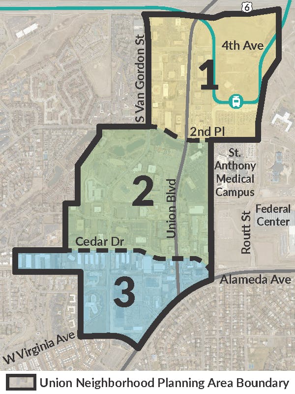
Share Why is the scope of participants you're asking so narrow? A project like this could significantly impact many more people than only those who live or work in the identified area. This is a very busy street at any time of day, but most notably rush hour times. This is a major road that people use for access to 6th Ave and many other areas, not too mention those who travel through this area to get to the federal center station. I live just south of the area highlighted, however I drive this road everyday. on Facebook Share Why is the scope of participants you're asking so narrow? A project like this could significantly impact many more people than only those who live or work in the identified area. This is a very busy street at any time of day, but most notably rush hour times. This is a major road that people use for access to 6th Ave and many other areas, not too mention those who travel through this area to get to the federal center station. I live just south of the area highlighted, however I drive this road everyday. on Twitter Share Why is the scope of participants you're asking so narrow? A project like this could significantly impact many more people than only those who live or work in the identified area. This is a very busy street at any time of day, but most notably rush hour times. This is a major road that people use for access to 6th Ave and many other areas, not too mention those who travel through this area to get to the federal center station. I live just south of the area highlighted, however I drive this road everyday. on Linkedin Email Why is the scope of participants you're asking so narrow? A project like this could significantly impact many more people than only those who live or work in the identified area. This is a very busy street at any time of day, but most notably rush hour times. This is a major road that people use for access to 6th Ave and many other areas, not too mention those who travel through this area to get to the federal center station. I live just south of the area highlighted, however I drive this road everyday. link
Why is the scope of participants you're asking so narrow? A project like this could significantly impact many more people than only those who live or work in the identified area. This is a very busy street at any time of day, but most notably rush hour times. This is a major road that people use for access to 6th Ave and many other areas, not too mention those who travel through this area to get to the federal center station. I live just south of the area highlighted, however I drive this road everyday.
Mmolly asked over 6 years agoHi there,
To address concerns about traffic on Union, City Council directed staff to work with the community to develop the Union Area Transportation Study in 2018. This current Union Neighborhood Vision Plan is to address the overall character of the neighborhood by creating goals for appropriate land uses, building and site design, and amenities. It will complement the Union Area Transportation Study. As with all community plans, the outreach for the Union Neighborhood Vision Plan is to those who live and work in the neighborhood, but we expanded the outreach to those adjacent to Union Boulevard. Direct mailings went to 2,100 addresses including 22 registered organizations about the upcoming meetings and survey. Posts with this information on 16 Nextdoors sites, which reached 4,262 residents, were also made.
Because we heard that outreach was too limited, we have added four Nextdoors posts, which will reach an additional 1,879 residents.
Thanks for your question! -
Share I just spent a long time filling out the survey for the first meeting. I answered all the questions for all 3 planning areas. I hit save and continue and suddenly I was back at question One. Was that the end of survey or did all my answers somehow go away. What does it say at the end of the survey? on Facebook Share I just spent a long time filling out the survey for the first meeting. I answered all the questions for all 3 planning areas. I hit save and continue and suddenly I was back at question One. Was that the end of survey or did all my answers somehow go away. What does it say at the end of the survey? on Twitter Share I just spent a long time filling out the survey for the first meeting. I answered all the questions for all 3 planning areas. I hit save and continue and suddenly I was back at question One. Was that the end of survey or did all my answers somehow go away. What does it say at the end of the survey? on Linkedin Email I just spent a long time filling out the survey for the first meeting. I answered all the questions for all 3 planning areas. I hit save and continue and suddenly I was back at question One. Was that the end of survey or did all my answers somehow go away. What does it say at the end of the survey? link
I just spent a long time filling out the survey for the first meeting. I answered all the questions for all 3 planning areas. I hit save and continue and suddenly I was back at question One. Was that the end of survey or did all my answers somehow go away. What does it say at the end of the survey?
wkaren06 asked over 6 years agoThanks for taking the time to fill out the survey! Once you've completed Area 3, the survey is complete. If you entered an email address at the beginning of the survey, you should have received a confirmation email acknowledging our receipt of your answers.
What are the goals of this plan?
The purpose of the plan is to create a set of goals that will provide guidance for future appropriate land uses, building and site design, and amenities in the neighborhood.
View the summary of the Final Recommendations survey!
Planning Area Map

Timeline
-
March 28, 2019: Union Neighborhood Vision Plan planning process begins!
The Union Neighborhood Vision Plan has finished this stageWe're live! Join us here as we imagine Union's future.
-
April 11, 2019: Community Meeting #1 - Vision
The Union Neighborhood Vision Plan has finished this stageJoin us at the Hampton Inn for our first meeting 6 - 8 p.m. Address: 137 Union Blvd.
-
May 8, 2019: Community Meeting #2 - Vision (REPEAT)
The Union Neighborhood Vision Plan has finished this stageThis meeting will repeat the April 11 meeting for those who were unable to attend.
-
June 6, 2019: Community Meeting #3 - Design
The Union Neighborhood Vision Plan has finished this stageJoin us at the Hampton Inn for our third meeting 6 - 8 p.m. Address: 137 Union Blvd.
-
June 27, 2019: Community Meeting #4 - Public Review of Draft Recommendations
The Union Neighborhood Vision Plan has finished this stageJoin us at the Hampton Inn for our fourth meeting 6 - 8 p.m. Address: 137 Union Blvd.
-
July 18, 2019: Meeting #5 - Final Review of Recommendations
The Union Neighborhood Vision Plan has finished this stageJoin us at the Hampton Inn for our fifth and final meeting 6 - 8 p.m. to review the final recommendations. Address: 137 Union Blvd.
-
August 19, 2019: City Council Study Session on Proposed Recommendations
The Union Neighborhood Vision Plan has finished this stage -
September 25, 2019: Planning Commission Public Hearing (Continued)
The Union Neighborhood Vision Plan has finished this stage -
October 16, 2019: Planning Commission Public Hearing (Continued)
The Union Neighborhood Vision Plan has finished this stage -
February 12, 2020: Planning Commission Study Session
The Union Neighborhood Vision Plan has finished this stage -
June 3, 2020: Planning Commission Study Session
The Union Neighborhood Vision Plan has finished this stage -
July 15, 2020: Planning Commission Public Hearing
The Union Neighborhood Vision Plan is currently at this stage
FAQ
- How will my input affect this plan?
- I can't make the meeting! How do I share my thoughts?
- Lakewood just completed the Union Area Transportation Study in 2018. How will this plan be different?
- How were the planning area boundaries determined?
- What is the status of the vacant property north of the Federal Center light rail station?
Explore the Area
Who's listening
-
Planner
CEmail chrhor@lakewood.org


